• Facebook
  • Instagram
  • LinkedIn
  • Sand Bypass System Jetty – Public Access Status
Gold Coast Waterways Authority
  • I Want To…
    • Explore Access & Management
      • Anchoring & Mooring
      • Boating
      • Buoy Moorings
      • Dredging
      • Speed Limits
      • Make a Report
      • Tidal Works
      • Marina Owner Levy
    • Visit A Destination
      • Visit Doug Jennings Park
      • Southern tip of South Stradbroke Island
      • Gold Coast Sand Bypass System
      • Wave Break Island
      • Maps
  • Our Projects
    • Current Projects
    • Completed Projects
    • Our Program
    • Work with Us
  • News & Community
    • News
    • Waterways Notices
    • Grants & Sponsorship
  • Events & Permits
    • Aquatic Events
    • Permits for Doug Jennings Park
  • Spit Master Plan
    • The Spit Stories
  • About
    • Our Board
    • Our Organisation
    • Vision & Strategy
    • Publications
    • Our Committees
  • Contact
  • Search
  • Menu Menu

Work starts on major enhancement to Gold Coast waterways gateway

February 8, 2021/in Project News/by ydsgcwa

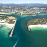
Preliminary works have started on a multi-million-dollar project to dredge an area near the Gold Coast Seaway entrance and in the adjacent navigation channels to improve access to the waterways network.

A contract to undertake sediment sampling for the project has been awarded to Gold Coast firm, Pacific Geotech Pty Ltd.

The Seaway is the gateway to the Gold Coast’s inland coastal waterways network and is a vital connection point for boaties.

The $6.3 million Seaway and North and South Channels dredging project will remove sand which has built up near the entrance to the Seaway and in the adjacent North and South Channels.

The result will be improved and safer access for boaties, especially small and medium vessels travelling through the Seaway.

The project will also ensure ongoing access for vessels coming in for maintenance and servicing, including superyachts. These visitors alone are worth tens of millions of dollars to the Gold Coast every year and support thousands of jobs.

The sediment sampling is being done to identify the type of material which will be removed during the dredging process so that GCWA can determine where it can be deposited as part of its Dredge Management Plan and Environmental Management framework.

The sampling process is expected to be completed in the next few weeks with dredging due to start in June this year.

It’s the first time in a decade that GCWA has had to dredge the Seaway.

GCWA CEO Hal Morris said the Sand Bypass System at the Spit has done a great job of keeping the Seaway open by transporting sand north to South Stradbroke Island.

‘Unfortunately, storm activity has brought some of that sand back in near the Seaway entrance over time, so we need to dredge the area.

‘We’ll dredge the North and South Channels at the same time to ensure boaties have clear access into the waterways network.’

Mr Morris said the dredging campaign should be finished by January 2022.

GCWA is planning to deposit the dredged sediment offshore from Narrowneck, Surfers Paradise and South Stradbroke Island beaches and Moondarewa Spit at The Spit to support coastal protection from storm surges.
https://gcwa.qld.gov.au/wp-content/uploads/2021/05/11025-46-m_from-GCCC-980x653-1.jpg 653 980 ydsgcwa https://gcwa.qld.gov.au/wp-content/uploads/2022/06/gold_coast_waterway_authority1.png ydsgcwa2021-02-08 14:47:242022-05-23 06:14:51Work starts on major enhancement to Gold Coast waterways gateway

Innovation gives GCWA eyes underwater

February 3, 2021/in Latest News/by ydsgcwa

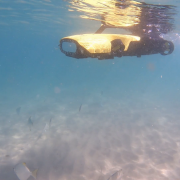
A remotely operated underwater vehicle (ROV) has been specially developed to enhance our knowledge of the Gold Coast’s underwater environments and improve waterways management.

The new Rangerbot named Nyah will do a range of jobs including marine habitat surveys, seabed sediment sampling, maintenance checks on navigation aids and to help search for, and retrieve, objects from the water.

Nyah is the Yugambeh word for ‘look see.’ The name was given to our newest team member by a Gold Coast Year 3 student who won a recent competition to name the robot.

Nyah was officially launched today by the Minister for Transport and Main Roads, Mark Bailey, who said the Rangerbot would add another dimension to the management and research skills of the GCWA team.

Nyah gives us the ability to do a deeper dive under the water and improve our understanding of what’s going on there, whether it’s surveying seagrass meadows or checking for potential marine hazards.

Nyah will provide access to real-time information needed to effectively manage an asset which has a natural capital value of $26 billion and supports thousands of jobs in the marine, tourism and recreation industries.

As a bonus, this is technology which has been developed locally by the Queensland University of Technology and adapted for use in Gold Coast waters.

Rangerbot Nyah comes equipped with multiple cameras enabling it to look above, behind, below and in front of itself, acoustic sensors to help with navigation and a special gripping arm for retrieving objects and scientific samples.

Nyah will enhance our planning and scientific research capabilities by enabling us to collect data to help us better understand the underwater environment and the impact factors such as climate change are having on marine environments, marine infrastructure and habitats.

It’ll also improve the efficiency and safety of our operations in, and under, the water.

In the past, we’ve had to engage specialist contractors to check damaged buoy moorings or navigation aids or to retrieve submerged objectives.

With Nyah on board, our Waterways team can quickly launch it and see what’s going on underwater in real time. They can use that information to help identify the problem more quickly and safely, allowing us to implement a solution faster.

Rangerbot Nyah may also be called upon by other agencies such as the Gold Coast water police and Maritime Safety Queensland to help with retrieval and rescue missions.

Rangerbot Nyah technical specifications:

  • 330-degree field of view to inspect below, above, behind or in front of the underwater ROV
  • forward speed of 5 knots, with depth ratings of 50m
  • ideal for underwater inspections in tough environments
  • flexible use as can provide GPS estimate of position for survey data and
  • ability to add monitoring equipment.
https://gcwa.qld.gov.au/wp-content/uploads/2021/02/Nyah-February-2021-980x551-1.png 551 980 ydsgcwa https://gcwa.qld.gov.au/wp-content/uploads/2022/06/gold_coast_waterway_authority1.png ydsgcwa2021-02-03 13:45:412022-05-23 06:15:52Innovation gives GCWA eyes underwater

–

  • Investing in the Sand Bypass System for the Future
  • Operation Clearwater delivers improvements for Gold Coast waterways
  • Operation Clearwater delivering results across the Broadwater
  • Gold Coast Seaway marks 40 years of coastal engineering and connectivity
  • GCWA Planning Framework Receives National Recognition
  • Joint agency operation steps up action across the Broadwater
  • Paradise Point Boat Ramp upgrade works now underway to improve safety and access
  • Supporting Cleaner Waterways Together at The Seaway
  • Keeping Our Waterways Safe: Compliance Results Delivered Across Gold Coast Waterways
  • New signage rollout completed at Muriel Henchman Park (The Spit Boat Ramps)

  • 40-44 Seaworld Drive
    Main Beach Qld 4217

  • PO Box 107
    Southport Qld 4215

  • 07 5539 7350
  • mail@gcwa.qld.gov.au

Who’s Who in the Blue

Who’s Who in the Blue explains who is responsible for managing, protecting and
regulating Queensland’s waterways, particularly on the Gold Coast.

It clarifies agency roles across safety, environmental protection, pollution response,
compliance and infrastructure, helping avoid confusion and duplication.

Overall, it’s a quick reference guide that supports coordination, accountability and
effective waterway stewardship.

Download Who’s Who in the Blue

Acknowledgement of Country

The Gold Coast Waterways Authority acknowledges and pays respect to the traditional custodians, the Yugambeh peoples of South East Queensland, including the Kombumerri, Mununjali, Wangerriburra, Bullongin and other clans, and their Elders past, present and emerging. We recognise their unique and ongoing spiritual and cultural connection with the land and waters of the Gold Coast area.

Any damaged or missing aids to navigation such as beacons, buoys, markers or signs, should be reported as soon as possible on 07 5539 7350.
For community engagement, communications or media enquiries please contact mail@gcwa.qld.gov.au

Access, Management & Destinations

  • Access & Management

    Information on Anchoring & Mooring, Boating, Dredging, Operations Team & Tidal Works

    Learn More

  • Our Destinations

    GCWA managed multi-use destinations, building infrastructure for commercial and recreation use of Gold Coast waterways.

    Learn More
© 2026 Copyright - Gold Coast Waterways Authority | Website By: YDS
  • Facebook
  • Instagram
  • LinkedIn
  • Right to Information
  • Privacy
  • Disclaimer
  • Copyright
Scroll to top

Status: Closed

The Sand Bypass System (SBS) jetty is a working platform and is closed to the public whenever construction activity, sand pumping operations or maintenance works are underway, or during severe weather events.

For safety reasons, the jetty will remain closed until the end of 2026 while essential maintenance and ongoing sand pumping operations continue. We appreciate your understanding.

To find alternative jetty facilities, please visit the GCWA Destinations Map.

Disclaimer

GCWA’s tidal works mapping is a public resource for general information purposes only.

The tidal works mapping is not a cadastral survey or hydrographic survey product. It should not be relied upon as the basis for making any decision, whether a business, conveyance, development, property boundary, property description, property title, property transaction, or any other decision.

GCWA makes no warranty, representation, or guarantee, express or implied, as to the accuracy, completeness, content, reliability, suitability, or timeliness, with respect to the information or related graphics.

GCWA has taken care in preparing the mapping information, but accuracy is not guaranteed, and the information contained in the tidal works mapping must not be construed or used as a legal description of any property. Under no circumstances will GCWA be liable for any damages whatsoever, including business interruption, loss of business information, loss of data, loss of profits, property valuation, or any other damage, arising from use or misuse of this tidal works mapping.

Any errors or omissions should be reported to GCWA in writing by email to mail@gcwa.qld.gov.au.


Status: Closed

The SBS jetty is a working platform and for safety reasons is not open to the public during construction projects, when operating, undergoing maintenance or during severe weather events.

Until the end of 2025 while maintenance works, and sand pumping operations take place, the jetty will be closed.

Your understanding is appreciated, to find alternative jetty facilities please visit the GCWA destinations map.

Disclaimer

Tidal works mapping information

GCWA’s tidal works mapping information is a public resource for general information purposes only. It is not a cadastral survey or hydrographic survey product. It should not be relied upon as the basis for making any decision, whether a business, conveyance, development, property boundary, property description, property title, property transaction, or any other decision. GCWA makes no warranty, representation, or guarantee, express or implied, as to the accuracy, completeness, content, reliability, suitability, or timeliness with respect to the information or related graphics. GCWA has taken care in preparing the mapping information, but accuracy is not guaranteed, and the information contained in the GCWA Open Data Portal must not be construed or used as a legal description of any property. Any errors or omissions should be reported to GCWA in writing by email to mail@gcwa.qld.gov.au. Under no circumstances will GCWA be liable for any damages whatsoever, including business interruption, loss of business information, loss of data, loss of profits, property valuation or any other or damage arising from use or misuse of this mapping information.

Go To GCWA Open Data Portal

I want to talk to someone about...

I want to talk to someone about… Officer Phone number
reporting oil pollution, a significant navigational hazard, or a damaged aid to navigation.Waterways Vision and Waterways Management Strategy Waterways Operations Crew 07 5539 7350
a media issue Senior Communications Advisor 07 5539 7350
a project Program Delivery team 07 5539 7350
the Sand Management Plan Planning and Innovation team 07 5539 7350
Waterways Access

·         Dredging

·         Public pontoons & other marine infrastructure

·         Sand Bypass

Program Delivery team 07 5539 7350
Waterways Management Waterways team 07 5539 7350
·         Anchoring and Mooring Compliance

·         Aquatic Events

·         Doug Jennings Park

·         Abandoned vessels

·         Aircraft take-off and landing permits

Waterways team 07 5539 7350

07 5539 7350

·Navigation Aids

·Signage

·Pollution

Waterways Operations Crew 07 5539 7350
Marinas Waterways team 07 5539 7350
Private pontoons, jetties & boat ramps Waterways team 07 5539 7350
Buoy Moorings Planning and Innovation team 07 5539 7350
Executive Governance 07 5539 7350
GCWA Board, CEO matters 07 5539 7350
Community Engagement, Sponsorships & Partnerships Community Engagement Officer 07 5539 7350
Business Management Business Services team 07 5539 7350
Accounts Payable – General Accounts Business Services team 07 5539 7350
Accounts Payable – Projects Program Delivery team 07 5539 7350
Accounts Receivable Business Services team 07 5539 7350
Sand Bypass Status

Status: Closed

The SBS jetty is a working platform and for safety reasons is not open to the public during construction projects, when operating, undergoing maintenance or during severe weather events.

Until the end of 2025 while maintenance works, and sand pumping operations take place, the jetty will be closed.

Your understanding is appreciated, to find alternative jetty facilities please visit the GCWA destinations map.