• Facebook
  • Instagram
  • LinkedIn
  • Sand Bypass System Jetty – Public Access Status
Gold Coast Waterways Authority
  • I Want To…
    • Explore Access & Management
      • Anchoring & Mooring
      • Boating
      • Buoy Moorings
      • Dredging
      • Speed Limits
      • Make a Report
      • Tidal Works
      • Marina Owner Levy
    • Visit A Destination
      • Visit Doug Jennings Park
      • Southern tip of South Stradbroke Island
      • Gold Coast Sand Bypass System
      • Wave Break Island
      • Maps
  • Our Projects
    • Current Projects
    • Completed Projects
    • Our Program
    • Work with Us
  • News & Community
    • News
    • Waterways Notices
    • Grants & Sponsorship
  • Events & Permits
    • Aquatic Events
    • Permits for Doug Jennings Park
  • Spit Master Plan
    • The Spit Stories
  • About
    • Our Board
    • Our Organisation
    • Vision & Strategy
    • Publications
    • Our Committees
  • Contact
  • Search
  • Menu Menu

Tidal Exchange Field Work at Marine Stadium

March 23, 2022/in Community/by ydsgcwa

We’re undertaking some field work in Marine Stadium as part of the implementation of The Spit Master Plan.

On Friday 25 March and 1 April 2022, a small amount of specially formulated dye will be released from a research vessel into the centre of Marine Stadium. Even though it will be at very low concentrations highly sensitive technical equipment will track its movement.

The specially formulated dye has no adverse effects on human health, local ecology or marine life at the low concentrations being used. It is certified to international standards for use in drinking water.

This field work will provide accurate and reliable data that will be used to create a hydrodynamic model. That model will then be used to assess potential solutions to increase tidal movements and recreational amenity.

GCWA has engaged experienced and qualified consultants, Seaport OPX with further guidance from former Director of the Griffith Centre for Coastal Management, Emeritus Professor Roger Tomlinson.

This is the first step towards a greater understanding of the flow of water within Marine Stadium.

Marine Stadium is expected to open to the community on Monday 4 April 2022. We apologise for any inconvenience.

For more information please visit our fact sheet.

https://gcwa.qld.gov.au/wp-content/uploads/2022/06/gold_coast_waterway_authority1.png 0 0 ydsgcwa https://gcwa.qld.gov.au/wp-content/uploads/2022/06/gold_coast_waterway_authority1.png ydsgcwa2022-03-23 19:07:482022-05-23 05:52:32Tidal Exchange Field Work at Marine Stadium

Marine Stadium Destination Plan Survey

September 10, 2021/in Community/by ydsgcwa

We’re planning for best future uses of Marine Stadium at The Spit, Main Beach, and we need your input.

Marine Stadium is an incredibly popular destination in our city, with a diverse range of use and users.

The Gold Coast Waterways Authority is preparing a draft plan for the best future uses for Marine Stadium, in collaboration with the City of Gold Coast and other relevant Queensland Government agencies.

Your survey responses will help us co-design a draft ‘Marine Stadium Destination Plan’, that strikes a balance between economic, environmental, cultural, and social values.

Please partner with us in co-designing the plan by completing the survey below. It should take about 10 minutes of your time.

https://www.surveymonkey.com/r/6R9DGXX

 Thank you, the GCWA team.


https://gcwa.qld.gov.au/wp-content/uploads/2021/09/marine-stadium3-980x735.jpg.webp 735 980 ydsgcwa https://gcwa.qld.gov.au/wp-content/uploads/2022/06/gold_coast_waterway_authority1.png ydsgcwa2021-09-10 16:00:502022-05-23 05:56:53Marine Stadium Destination Plan Survey

Sand Bypass System jetty access update

May 7, 2021/in Community/by ydsgcwa

We’re closing the jetty to public access this weekend (8-9 May 2021,) and the following 3 weekends, as we’ll be pumping sand during these times.

The jetty was built to support the jet pumps for the Sand Bypass System.

To make sure we keep pace with changes in health and safety regulations, GCWA regularly undertakes risk assessments of its assets.

A recent risk assessment of the Sand Bypass System recommended that we do not open the jetty to the public when sand is being pumped, for safety reasons.

The assessment also recommended that we no longer open the jetty at night because of inadequate lighting and restricted access for emergency services.

Our pumping schedule is determined by natural conditions such as swell direction and height, wind direction and sand build-up caused by those conditions. Typically these conditions prevail from April until October.

We also choose to pump at night and at weekends to take advantage of lower, off-peak electricity prices.


https://gcwa.qld.gov.au/wp-content/uploads/2021/05/SandByPassJetty-980x656.jpg.webp 656 980 ydsgcwa https://gcwa.qld.gov.au/wp-content/uploads/2022/06/gold_coast_waterway_authority1.png ydsgcwa2021-05-07 14:04:202022-11-24 22:44:58Sand Bypass System jetty access update

Our waterways, our future – 2020 wrap-up

December 22, 2020/in Community/by ydsgcwa

What a year 2020 has been.

Whilst COVID-19 has certainly thrown us some curve balls, we’ve been inspired by the willingness of people to work together and help each other out. We hope that continues in 2021 so that the Gold Coast, and the wider community, bounces back to be more resilient than ever.

We want to especially thank the community members who’ve navigated the challenges of technology and social distancing to participate in our Meet the Board events and our consultation sessions on our Strategy update and the next round of Spit Master Plan projects. Your input is vital and continues to guide the important work we do in managing our beautiful waterways.

Follow this link to read the full 2020 wrap-up

https://gcwa.qld.gov.au/wp-content/uploads/2020/12/shutterstock_767464711-980x550-1.jpg 550 980 ydsgcwa https://gcwa.qld.gov.au/wp-content/uploads/2022/06/gold_coast_waterway_authority1.png ydsgcwa2020-12-22 14:27:412022-05-23 06:19:02Our waterways, our future – 2020 wrap-up

Our waterways, our future – share your views

November 4, 2020/in Community/by ydsgcwa

We’re refreshing our Gold Coast Waterways Strategy and we’d like to hear your views on what the future of the waterways looks like over the next ten years.

To help us plan ahead, we’re inviting you to fill out this short survey.

It’ll only take a couple of minutes and will put you in the running to win a voucher from Doug Burt’s Tackle World Gold Coast.

Please read the full Terms and Conditions here.

https://gcwa.qld.gov.au/wp-content/uploads/2020/11/shutterstock_143764606-980x653-1.jpg 653 980 ydsgcwa https://gcwa.qld.gov.au/wp-content/uploads/2022/06/gold_coast_waterway_authority1.png ydsgcwa2020-11-04 15:25:072022-05-23 06:30:09Our waterways, our future – share your views

2019-2020 Annual Report

September 28, 2020/in Community/by ydsgcwa

In 2019-2020 the Gold Coast Waterways Authority has delivered on key infrastructure, waterways management and research objectives which have been part of our longer-term planning, unlocking more opportunities for local businesses, recreational users and visitors to our waterways city.

We’ve supported safe access to our waterways by continuing to dredge navigational channels, issuing almost 200 permits for events water and in Doug Jennings Park, upgrading boating infrastructure and maintaining more than 2,000 beacons, buoys and marine signs.

You can find out more about the work we’ve done to Sustain, Enhance and Promote our beautiful waterways in our 2019-2020 Annual Report

https://gcwa.qld.gov.au/wp-content/uploads/2022/06/gold_coast_waterway_authority1.png 0 0 ydsgcwa https://gcwa.qld.gov.au/wp-content/uploads/2022/06/gold_coast_waterway_authority1.png ydsgcwa2020-09-28 08:59:502022-05-23 06:31:362019-2020 Annual Report

Meet the Board

August 1, 2020/in Community, Upcoming Events/by ydsgcwa

The Board is committed to setting priorities locally. Meet The Board sessions are held regularly throughout the Gold Coast to provide community members with the opportunity to provide their input on planning for the waterways now and into the future.

According to the GCWA Chairman, Mara Bún, the role of the community in planning for the waterways now and into the future is vital. The seven-member Board of the GCWA has backed this commitment by meeting with thousands of residents over the past few years to seek their views. We’ve talked with everyone from boaties to divers, waterskiers to jetskiers, residents and visitors to shape our priorities.

To be kept up to date about upcoming Meet the Board sessions and all things waterways, make sure you sign up to our e-newsletter and like us on Facebook.

Subscribe to our e-newsletter

NEXT MEET THE BOARD | SOUTHERN GOLD COAST

MONDAY 10 AUGUST 2020

6.30PM – 7.30PM
Currumbin RSL
165 Duringan St Currumbin QLD 4223

Register to attend Meet The Board in person

Due to COVID-19, our meeting is strictly limited to 30 community members attending. As a result, we will be digitally streaming the event for those at home who are unable to attend.

To register for the digital Webinar, please click here.


https://gcwa.qld.gov.au/wp-content/uploads/2022/06/gold_coast_waterway_authority1.png 0 0 ydsgcwa https://gcwa.qld.gov.au/wp-content/uploads/2022/06/gold_coast_waterway_authority1.png ydsgcwa2020-08-01 08:00:232022-05-23 06:41:58Meet the Board

New-style moorings to protect environment

June 5, 2020/in Community/by ydsgcwa

We’ve taken the first steps towards introducing Environmentally Friendly Moorings (EFMs) into Gold Coast waters.

As part of our Buoy Mooring Management Strategy , and in partnership  with Healthy Land and Water (HLW,) we’ve supported the installation of 22 EFMs in the southern part of the Moreton Bay Marine Park at Jacobs Well (pictured above) and Steiglitz (Cabbage Tree Point.)

The EFMs replace the traditional block and tackle swing moorings that generally consist of a heavy block that sits on the seabed attached to tackle, typically a heavy chain which is attached to another chain and/or rope and a mooring buoy.

The chains drag along the seabed as the vessel moves with the wind and tide, disturbing the seabed and damaging seagrass. The seagrass provides food and shelter for marine species such as juvenile fish, dugongs, turtles, crabs and seahorses. Seagrass meadows also help stabilise seabeds and shorelines, reducing erosion.

EFMs, by contrast, typically use a screwed-in mooring post as the anchor point with a swivel head and a specialised shock absorber which connects to a cable rope and surface buoy. This means that apart from the anchor, none of the equipment contacts the seafloor. Without a heavy chain dragging on the seafloor, the EFMs allow vessels to swing around more freely and frequently without causing a dragging motion, reducing constant shading of marine plants which can limit growth.

HLW will monitor the area over a number of years to assess how well the seagrass beds are recovering following the installation of the new moorings.

GCWA and Healthy Land and Water worked closely with existing buoy mooring owners to transition them to the EFMs.

In line with the Buoy Mooring Management Strategy, our Board has decided that from mid-2024, every buoy mooring will transition to an EFM.

You can read more about our Buoy Mooring Management Strategy here https://www.ydsgroup2.com.au/oldgcwa/wp-content/uploads/2017/03/BuoyMooringMStrategyFinalAug17.pdf

https://gcwa.qld.gov.au/wp-content/uploads/2020/06/JW-Consolidated-St-East-60m-1-980x653-1.png 653 980 ydsgcwa https://gcwa.qld.gov.au/wp-content/uploads/2022/06/gold_coast_waterway_authority1.png ydsgcwa2020-06-05 12:13:542022-05-23 06:50:45New-style moorings to protect environment

Landmark light study protects blooming seagrass

February 26, 2020/in Community, Environment / Science/by ydsgcwa

Study into light sensitivity of Gold Coast seagrass meadows to guide improved management

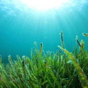
A landmark study into the light sensitivity of Gold Coast seagrass meadows has pinpointed how much light these vital sea life breeding and feeding grounds need to grow and thrive.

The study, undertaken by Griffith University on behalf of the Gold Coast Waterways Authority (GCWA,) looked at the impacts of light levels on growth and survival rates of seagrass meadows.

Seagrass light sensitivity has been the subject of research on the Great Barrier Reef but hasn’t been investigated on the Gold Coast where seagrass meadows live in different environmental conditions.

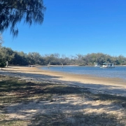
The Gold Coast is home to about 1,100 hectares (about 11 square kilometres) of seagrass meadows which provide food and shelter for marine species like dugongs, turtles and seahorses and which stabilise seabeds and shorelines, reducing erosion.

GCWA’s Chair, Mara Bún said seagrass also plays a vital role in responding to climate change because it’s able to store carbon faster than land-based plants making it an effective carbon sink.

‘These green assets contribute to the overall health and natural capital value of our waterways, which has been estimated at $26 billion. They form part of our blue economy which is internationally delivering strong economic value. As a carbon sink seagrass meadow have enormous potential to deliver economic benefits to our waterways city.

‘This study has given us a better understanding of how seagrass responds to light which will help us decide what we need to do to make sure that activities which have the potential to adversely impact seagrass growth are carefully managed to ensure these meadows are protected and nurtured.

‘The study has come up with a recommended minimum number of hours of light exposure needed to maintain seagrass health. Those time periods will vary depending on the location of the seagrass, direct exposure to sunlight and time of day.

‘We’ll work to incorporate those recommendations into activities such as our dredging programs for example, to minimise impacts on seagrass meadows so these marine nurseries are happy and healthy.’

Ms Bún said the inclusion of light sensitivity thresholds adds to other measures GCWA is undertaking to improve seagrass protection including undertaking seagrass surveying and mapping prior to dredging programs commencing and regular water quality monitoring during dredging campaigns.

Griffith University project lead, Professor Rod Connolly, said the research team assessed a range of data points including solar strength, cloud cover, wind speed and direction, boating traffic in areas being studied, water depth, distance from ocean inlets and time of day.

‘Over 9 months of field experiments we took millions of underwater light measurements which scientifically support the new management recommendations’.

https://gcwa.qld.gov.au/wp-content/uploads/2020/02/shutterstock_142303630-980x653-1.jpg 653 980 ydsgcwa https://gcwa.qld.gov.au/wp-content/uploads/2022/06/gold_coast_waterway_authority1.png ydsgcwa2020-02-26 16:02:452022-05-23 07:22:06Landmark light study protects blooming seagrass

Sand Bank Study In Southern Broadwater Supports Better Waterways Management

May 8, 2019/in Community, Environment / Science, Latest News/by ydsgcwa

We’re conducting a long-term study into the birds and animals living on and within the sand banks of the Southern Broadwater to help with the management of threatened species and support the protection of the Gold Coast’s waterways environmental values.

With the waterways having a natural capital value of $26 billion it’s important to ensure they’re properly managed now and into the future.

We need to adapt our planning practices to manage the likely impacts of climate change and population growth on our waterways so that they remain accessible to our marine and tourism industries and for recreational use.

This study will help us do that by providing valuable base-line data we can feed into management plans and use to assess potential risks to the birds and marine life which call these areas home.

The study will focus on the sand banks near Wave Break and Curlew Islands which have been identified as foraging areas for shorebirds such as the Critically Endangered Eastern Curlew.

This is the first time we’ve done a formal survey of the banks and the creatures living on and within them.

Improving our understanding of these areas gives us the chance to anticipate changes which might be triggered by population growth and climate change and head off any adverse impacts.

We’ve engaged a final-year student to undertake the study as part of our participation in Griffith University’s Industry Affiliates Program.

The Spit Master Plan has identified Wave Break and Curlew Islands as popular recreation areas and we need to ensure that they’re managed in a way that enables people to enjoy them for years to come.

The study will focus on benthic organisms which are organisms living in the sand bank surface down to a depth of about 20 centimetres.

We’re aiming to map the sensitivity of the sandbanks and better understand the ecological processes which take place on them such as the relationship between the marine life in the benthic layer and the numbers of shorebirds and their feeding habits.

Information gathered will also be fed into the GCWA’s Sand Management Plan which determines where and how sand recovered through dredging is used for shoreline replenishment and the impact that process has on creatures living in the benthic layer.

The study will concentrate on:

  • Identifying any invertebrates found in the benthic zone such as worms
  • Examining sediment particles to determine size and how they’re distributed on the banks
  • Counting shorebirds and
  • Reviewing any existing mapping.

It’s anticipated that the study will take place over several years, enabling the GCWA to build up a solid understanding of the ecological significance of the sand banks and adjust their management as needed.

https://gcwa.qld.gov.au/wp-content/uploads/2022/06/gold_coast_waterway_authority1.png 0 0 ydsgcwa https://gcwa.qld.gov.au/wp-content/uploads/2022/06/gold_coast_waterway_authority1.png ydsgcwa2019-05-08 12:53:372022-05-23 13:46:35Sand Bank Study In Southern Broadwater Supports Better Waterways Management
Page 2 of 3123

–

  • Operation Clearwater delivering results across the Broadwater
  • Gold Coast Seaway marks 40 years of coastal engineering and connectivity
  • GCWA Planning Framework Receives National Recognition
  • Joint agency operation steps up action across the Broadwater
  • Paradise Point Boat Ramp upgrade works now underway to improve safety and access
  • Supporting Cleaner Waterways Together at The Seaway
  • Keeping Our Waterways Safe: Compliance Results Delivered Across Gold Coast Waterways
  • New signage rollout completed at Muriel Henchman Park (The Spit Boat Ramps)
  • Marine Stadium recreational opportunities area extended to March 2027
  • Gold Coast Waterways Authority Welcomes Korean Delegation

  • 40-44 Seaworld Drive
    Main Beach Qld 4217

  • PO Box 107
    Southport Qld 4215

  • 07 5539 7350
  • mail@gcwa.qld.gov.au

Any damaged or missing aids to navigation such as beacons, buoys, markers or signs, should be reported as soon as possible on
07 5539 7350

For community engagement, communications or media enquiries please contact mail@gcwa.qld.gov.au

Need Assistance?

Who’s Who in the Blue

Who’s Who in the Blue explains who is responsible for managing, protecting and regulating Queensland’s waterways, particularly on the Gold Coast.

It clarifies agency roles across safety, environmental protection, pollution response, compliance and infrastructure, helping avoid confusion and duplication.

Overall, it’s a quick reference guide that supports coordination, accountability and effective waterway stewardship.

https://gcwa.qld.gov.au/wp-content/uploads/2025/12/Whos-Who-in-the-Blue-v4-004.pdf

Access, Management & Destinations

  • Access & Management

    Information on Anchoring & Mooring, Boating, Dredging, Operations Team & Tidal Works

    Learn More

  • Our Destinations

    GCWA managed multi-use destinations, building infrastructure for commercial and recreation use of Gold Coast waterways.

    Learn More

Acknowledgement of Country

The Gold Coast Waterways Authority acknowledges and pays respect to the traditional custodians, the Yugambeh peoples of South East Queensland, including the Kombumerri, Mununjali, Wangerriburra, Bullongin and other clans, and their Elders past, present and emerging. We recognise their unique and ongoing spiritual and cultural connection with the land and waters of the Gold Coast area.

© 2026 Copyright - Gold Coast Waterways Authority | Website By: YDS
  • Facebook
  • Instagram
  • LinkedIn
  • Right to Information
  • Privacy
  • Disclaimer
  • Copyright
Scroll to top

Status: Closed

The Sand Bypass System (SBS) jetty is a working platform and is closed to the public whenever construction activity, sand pumping operations or maintenance works are underway, or during severe weather events.

For safety reasons, the jetty will remain closed until the end of 2026 while essential maintenance and ongoing sand pumping operations continue. We appreciate your understanding.

To find alternative jetty facilities, please visit the GCWA Destinations Map.

Disclaimer

GCWA’s tidal works mapping is a public resource for general information purposes only.

The tidal works mapping is not a cadastral survey or hydrographic survey product. It should not be relied upon as the basis for making any decision, whether a business, conveyance, development, property boundary, property description, property title, property transaction, or any other decision.

GCWA makes no warranty, representation, or guarantee, express or implied, as to the accuracy, completeness, content, reliability, suitability, or timeliness, with respect to the information or related graphics.

GCWA has taken care in preparing the mapping information, but accuracy is not guaranteed, and the information contained in the tidal works mapping must not be construed or used as a legal description of any property. Under no circumstances will GCWA be liable for any damages whatsoever, including business interruption, loss of business information, loss of data, loss of profits, property valuation, or any other damage, arising from use or misuse of this tidal works mapping.

Any errors or omissions should be reported to GCWA in writing by email to mail@gcwa.qld.gov.au.


Status: Closed

The SBS jetty is a working platform and for safety reasons is not open to the public during construction projects, when operating, undergoing maintenance or during severe weather events.

Until the end of 2025 while maintenance works, and sand pumping operations take place, the jetty will be closed.

Your understanding is appreciated, to find alternative jetty facilities please visit the GCWA destinations map.

Disclaimer

Tidal works mapping information

GCWA’s tidal works mapping information is a public resource for general information purposes only. It is not a cadastral survey or hydrographic survey product. It should not be relied upon as the basis for making any decision, whether a business, conveyance, development, property boundary, property description, property title, property transaction, or any other decision. GCWA makes no warranty, representation, or guarantee, express or implied, as to the accuracy, completeness, content, reliability, suitability, or timeliness with respect to the information or related graphics. GCWA has taken care in preparing the mapping information, but accuracy is not guaranteed, and the information contained in the GCWA Open Data Portal must not be construed or used as a legal description of any property. Any errors or omissions should be reported to GCWA in writing by email to mail@gcwa.qld.gov.au. Under no circumstances will GCWA be liable for any damages whatsoever, including business interruption, loss of business information, loss of data, loss of profits, property valuation or any other or damage arising from use or misuse of this mapping information.

Go To GCWA Open Data Portal

I want to talk to someone about...

I want to talk to someone about… Officer Phone number
reporting oil pollution, a significant navigational hazard, or a damaged aid to navigation.Waterways Vision and Waterways Management Strategy Waterways Operations Crew 07 5539 7350
a media issue Senior Communications Advisor 07 5539 7350
a project Program Delivery team 07 5539 7350
the Sand Management Plan Planning and Innovation team 07 5539 7350
Waterways Access

·         Dredging

·         Public pontoons & other marine infrastructure

·         Sand Bypass

Program Delivery team 07 5539 7350
Waterways Management Waterways team 07 5539 7350
·         Anchoring and Mooring Compliance

·         Aquatic Events

·         Doug Jennings Park

·         Abandoned vessels

·         Aircraft take-off and landing permits

Waterways team 07 5539 7350

07 5539 7350

·Navigation Aids

·Signage

·Pollution

Waterways Operations Crew 07 5539 7350
Marinas Waterways team 07 5539 7350
Private pontoons, jetties & boat ramps Waterways team 07 5539 7350
Buoy Moorings Planning and Innovation team 07 5539 7350
Executive Governance 07 5539 7350
GCWA Board, CEO matters 07 5539 7350
Community Engagement, Sponsorships & Partnerships Community Engagement Officer 07 5539 7350
Business Management Business Services team 07 5539 7350
Accounts Payable – General Accounts Business Services team 07 5539 7350
Accounts Payable – Projects Program Delivery team 07 5539 7350
Accounts Receivable Business Services team 07 5539 7350
Sand Bypass Status

Status: Closed

The SBS jetty is a working platform and for safety reasons is not open to the public during construction projects, when operating, undergoing maintenance or during severe weather events.

Until the end of 2025 while maintenance works, and sand pumping operations take place, the jetty will be closed.

Your understanding is appreciated, to find alternative jetty facilities please visit the GCWA destinations map.