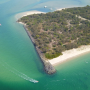
Following the successful completion of our Coomera River dredging campaign, we’re getting ready to start our next dredging project. As part of our Waterways Management Program, we will be dredging the South Wave Break Island Channel to ensure safe and navigable access to our waterways city.
Surveys of the channel have shown there’s shoaling. This means available depths have been reduced to less than 1 metre below Lowest Astronomical Tide (LAT) so we need to undertake maintenance dredging to keep this popular channel safe and navigable for boaties.
The dredging also enables us to undertake sand replenishment on Wave Break Island to build the resilience of the beaches and rock walls to storm surges.
If you’re interested in knowing more, keep reading on below or check out our project fact sheet here.
Q Why are we dredging the South Wave Break Island channel?
We’re undertaking several dredging projects this financial year as part of our $20 million Waterways Management Program.
Under the Gold Coast Waterways Act 2012 we dredge channels to maintain safe, navigational access.
The South Wave Break Island Channel is a vital link in our waterways network because it connects the eastern and western areas of the Broadwater.
Surveys of the channel have shown there’s shoaling. This means available depths have been reduced to less than 1 metre below Lowest Astronomical Tied (LAT.) We need to undertake maintenance dredging to keep this popular channel safe and navigable.
Q When was the last time this channel was dredged?
This channel is regularly dredged to maintain safe access and navigation for waterways users, it has been dredged seven times in the last 33 years. The last maintenance dredging was done in 2016.
Q What is the economic impact/benefit of this project?
Access to our waterways is vital for the Gold Coast’s tourism, recreation and marine industries.
Our waterways contribute $770 million directly and indirectly to our local economy each year and support 6,000 direct and indirect jobs.
We’re investing $500,000 in this project to ensure the Gold Coast continues to enjoy the economic and social benefits provided through access to our waterways.
Q What is the environmental impact of this project?
Environmental impacts are expected to be minimal because the material being dredged is clean sand, which is similar to the sand on the beach where it will be placed.
Initially the material discharging onto the foreshore from the pipe may have a dark or dirty appearance, which is normal. However, the colour of the sand will return to normal over a period of a few weeks as it is bleached by the sun and washed by the waves breaking on the foreshore.
A silt curtain may be placed in the waterway if needed to help settle the suspended sand.
Q Have any seagrass surveys been undertaken in the project area?
The planning process for all dredging projects includes undertaking pre-dredge seagrass surveys around the project area to identify any seagrass communities which may potentially be impacted as a result of the proposed works.
A delivery method for the dredging and beach nourishment works is then devised which considers any identified seagrass locations and minimises any impacts to these sites.
This includes:
- discharging the dredged material onto the upper section of the beach to aid settlement of sediment before it enters the waterway
- possible use of a silt curtain in the waterway adjacent to the discharge location
- implementation of a continuous water quality monitoring program which is compliant with Environmental Authority requirements and includes ongoing visual monitoring and water quality testing.
Following completion of the dredging program GCWA will carry out a post-dredge seagrass survey to identify if there has been any significant residual impact to seagrass communities as a result of the works.
Q Is seagrass present at this dredging location?
An initial survey indicated that there are seagrass meadows on the western side of Wave Break Island and the southern edges of Curlew Island. We don’t expect these areas to be impacted because of their distance from the dredging and beach nourishment activities.
Our recent surveys have shown some seagrass near the channel and the proposed placement areas. The survey will be used to determine if any design changes are needed before dredging commences and to mitigate any possible impacts to seagrass at these locations.
Q What sort of baseline studies and investigations have been done as part of the planning for this project?
- Sediment sampling and analysis
- Seagrass surveys
- Desktop investigations to understand potential impacts to flora and fauna and particularly matters of Federal, State and local significance
- Hydrographic surveys to understand shoaling and
- Cultural Heritage investigations.
Q Apart from dredging, what other activities can impact seagrass?
Increases in air and sea surface temperatures and salinity levels linked to climate change may cause burn off and damage to seagrass.
Catchment runoff (for example storm water) can cause poor water quality because of increased sediment and nutrient levels. This can affect seagrass because of lack of light and competition from algal growth caused by high nutrient levels. Poor water quality may be exacerbated by storms and flood events.
Habitat loss and modification from coastal development and/or port expansion.
Physical damage from direct human disturbance such as boat anchoring and construction of structures such as jetties.
Q Have any other seagrass studies been done outside dredging surveys?
A number of seagrass studies have been completed in the past that identify the location, density and health of the seagrass communities in the Broadwater. These studies are used in the project planning phase to inform future dredging works so outcomes can be devised that minimise impacts to seagrass meadows and the environment.
A comprehensive survey which has been used to inform the selection of likely locations for more recent pre-dredge surveys was undertaken in conjunction with Griffith University.
Q How was the sand replenishment area chosen?
The nourishment areas have been selected because they’re near the area being dredged and there’s need for ongoing replenishment of the foreshore of Wave Break Island to build the resilience of the beaches and rock walls to storm surges.
Wave Break Island was created in 1985 as part of the Gold Coast Seaway construction project to protect the western foreshore of the Broadwater from storm surges.
The eastern foreshore of Wave Break Island requires continuous nourishment to replenish sand that is continuously eroded from this location by the natural coastal process such as waves, currents and tides.
The sand we’re placing on Wave Break Island is clean sand which is similar to the sand on the beach where it will be placed.
Q Why can’t we place the dredged material further inland on the island?
Environmental best practice is to retain the sand within the active system (tidal zone).
Any removal of sand from the tidal zone onto land is considered extraction (sand mining).
We do not have approval to extract sand and place it inland on Wave Break Island.
Placing the sand inland may also adversely impact plants and wildlife habitat. Database searches of species records show that the island may be potential habitat for significant species including nesting habitat for the endangered little tern (Sternula albifrons) which is known to breed on Wave Break Island (VDM Consulting, 2012 – Ecological Investigations to Support the Broadwater Masterplan).
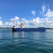
Q What type of dredge is being used?
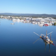
A Cutter Suction Dredge will be used for this dredging project. The dredge is built on pontoons that can be dismantled for transport purposes. The dredge uses front anchors with winches to move the vessel from side to side. Fixed and moveable spuds at the rear of the dredge push the vessel forward. The dredge’s suction pipe has a cutter head at the suction inlet to loosen the material and transport it to the suction pipe mouth. The cutter head can also be used for hard materials such as gravel and rock. The dredged material is sucked up by a centrifugal pump and discharged through a pipeline to the placement location.
Q There have been reports of dugongs and turtles being seen in the area, what steps will be taken to protect marine life from death and injury?
Various steps will be taken to prevent harm to wildlife:
- visual observations for marine fauna will be conducted before the start of dredging. Dredging will stop if marine fauna is sighted within 100 m of the dredge
- Conducting continuous water quality monitoring and testing for pollutants and litter
- Dredge operations will commence only when the dredge head is on the seafloor and will stop prior to the head being raised to minimise potential impacts to fauna
- Daytime operations only to avoid using artificial lighting which may cause disruption to wildlife, including shorebirds and turtles
- Biosecurity Queensland requirements are to be followed by the dredge operator to minimise/remove the risk of introduction of pest species into Gold Coast waterways.
- Dredge operator to follow strict requirements with regards to preventing and checking for leaks and spills to the environment and
- GCWA’s in-house environmental team and specialist water quality consultants will closely monitor the works.
Q Local tourism businesses claim dredging will reduce visibility and harm their business, what steps are you taking to minimise impacts?
As part of our pre-dredging consultation we’ve spoken to several local tourism operators who use Wave Break Island for diving, snorkelling and kayaking. We’re working with them to address concerns they’ve raised about potential impacts on their businesses during the project.
We’ll be undertaking robust environmental monitoring, including water quality monitoring in accordance with the Department of Environment and Science environmental approval requirements, to assess turbidity levels in addition to other water quality parameters.
Water quality monitoring will be undertaken prior to, and during dredging operations, at sites adjacent to dredging and beach nourishment locations to ensure any impacts to turbidity levels are identified and managed as quickly as possible and in the best way possible.
In addition to assessing localised turbidity during works, broader water quality testing and marine fauna and seagrass monitoring is also being undertaken to protect local environment values on a longer-term basis.
Q Have you changed anything about your dredging methods since you last dredged in this area?
The methodology for the beach nourishment has been modified by reducing the nourishment area on the eastern foreshore of Wave Break Island by approximately 50% and by limiting this to the southern section of the beach because this is further away from the location that dive operators use to carry out their activities.
Q Are there other locations in the Broadwater suitable for diving?
Yes. The southern seaway wall is an alternative and popular dive site which will remain accessible during the dredging campaign.
Q When is dredging due to commence?
We’re aiming to start dredging in late November and be finished by early December ahead of the Christmas holidays.