
Sand Bypass System Jetty Upgrade
Gold Coast Waterways Authority is undertaking essential maintenance and replacing several guide rails on the Sand Bypass System jetty.

Gold Coast Waterways Authority is undertaking essential maintenance and replacing several guide rails on the Sand Bypass System jetty.

The Gold Coast Waterways Authority is improving access and connections to the waterways by dredging the North Channel and South Channel navigation channels adjacent to the Seaway. Approximately 70,000 cubic metres of sand will be removed from the channel and beneficially reused.
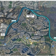
The Gold Coast Waterways Authority is improving access and connections to the waterways by dredging the Coomera River navigation channel from Sovereign Island to the Gold Coast Marine Industry Precinct at Coomera. Approximately 70,000 cubic metres of sand will be removed from the channel and beneficially reused.
A popular bay at the Top of The Spit in Main Beach has been opened to a broader range of recreational uses under a new 12-month trial that separates powered watercraft from passive recreation activity.
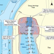
The Gold Coast Waterways Authority’s Recreation Uses Trial in Marine Stadium will support the transition from a predominantly long-term anchoring site to an area that supports a range of recreation activities.
At the centre of the trial activated on Friday 31 March is a Recreation Opportunities Area in the northern 300 metres of Marine Stadium which will be reserved for non-powered watercraft, freeing up the space for passive leisure opportunities such as fishing, sailing, stand-up paddle boarding and kayaking.
Powered watercraft can access the new jetty and pontoon through a 45-metre-wide channel and dedicated use area for dropping off passengers and vessel manoeuvring.
GCWA Chief Executive Chris Derksema said the Recreation Uses Trial was a significant step towards realising the full potential of Marine Stadium as a waterways destination that everyone can enjoy.
“This trial is a significant step towards fulfilling the vision of Marine Stadium outlined in line with The Spit Master Plan’s (2019),” Mr Derksema said.
“The community feedback we’ve received for Marine Stadium has been overwhelmingly in support of a shift to improved access to the water by limiting the number of vessels anchored in this area.
“We have also listened to concerns about the impacts of long-term anchoring on water quality which have been verified by the Marine Stadium Tidal Exchange Study.”
The study recommended GCWA adopt a management option that separates vessels from other recreational uses is the most effective way of supporting a range of recreational activities within Marine Stadium. The establishment of a recreational opportunities area responds directly to this recommendation.
Mr Derksema said the trial was underpinned by a Waterways Notice which outlines the regulations for vessels using each of the areas established in the Recreation Opportunities Area.
“We think this management option strikes the right balance between continuing to allow access by boat users, but also opens up the area to others,” he said.
“The Waterways Notice clearly sets out the perimeters of the new recreation opportunities area, the jetty and pontoon use area, and the approach channel into Marine Stadium.
“We will monitor and evaluate how the trial is performing throughout the year.”
The Recreation Uses Trial zone includes:
Download the Fact sheet here: Waterways Value Fact sheet
The full report can be read here: Socio-economic uses and economic value study of the Gold Coast Waterways

Any damaged or missing aids to navigation such as beacons, buoys, markers or signs, should be reported as soon as possible on
07 5539 7350
For community engagement, communications or media enquiries please contact mail@gcwa.qld.gov.au
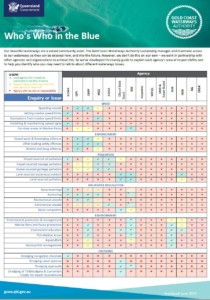
Who’s Who in the Blue explains who is responsible for managing, protecting and regulating Queensland’s waterways, particularly on the Gold Coast.
It clarifies agency roles across safety, environmental protection, pollution response, compliance and infrastructure, helping avoid confusion and duplication.
Overall, it’s a quick reference guide that supports coordination, accountability and effective waterway stewardship.
The Gold Coast Waterways Authority acknowledges and pays respect to the traditional custodians, the Yugambeh peoples of South East Queensland, including the Kombumerri, Mununjali, Wangerriburra, Bullongin and other clans, and their Elders past, present and emerging. We recognise their unique and ongoing spiritual and cultural connection with the land and waters of the Gold Coast area.