• Facebook
  • Instagram
  • LinkedIn
  • Sand Bypass System Jetty – Public Access Status
Gold Coast Waterways Authority
  • I Want To…
    • Explore Access & Management
      • Anchoring & Mooring
      • Boating
      • Buoy Moorings
      • Dredging
      • Speed Limits
      • Make a Report
      • Tidal Works
      • Marina Owner Levy
    • Visit A Destination
      • Visit Doug Jennings Park
      • Southern tip of South Stradbroke Island
      • Gold Coast Sand Bypass System
      • Wave Break Island
      • Maps
  • Our Projects
    • Current Projects
    • Completed Projects
    • Our Program
    • Work with Us
  • News & Community
    • News
    • Waterways Notices
    • Grants & Sponsorship
  • Events & Permits
    • Aquatic Events
    • Permits for Doug Jennings Park
  • Spit Master Plan
    • The Spit Stories
  • About
    • Our Board
    • Our Organisation
    • Vision & Strategy
    • Publications
    • Our Committees
  • Contact
  • Search
  • Menu Menu

It’s been a very busy year in our Waterways City!

December 24, 2019/in Latest News/by ydsgcwa

It’s been a very busy year in our Waterways City! Check out what we achieved in 2019 and what our plans for next year at the below link:

Gold Coast Waterways Authority 2019-2020

Have a happy and safe New Year. We look forward to an even bigger 2020!

https://gcwa.qld.gov.au/wp-content/uploads/2019/12/shutterstock_1150256906-980x654-1.jpg 654 980 ydsgcwa https://gcwa.qld.gov.au/wp-content/uploads/2022/06/gold_coast_waterway_authority1.png ydsgcwa2019-12-24 09:48:422022-05-23 07:29:05It’s been a very busy year in our Waterways City!

Court supports Wave Break Island clean-up

October 11, 2019/in Latest News/by ydsgcwa

With the busy summer season approaching, the Gold Coast Waterways Authority (GCWA) is reminding visitors to Wave Break Island that the popular Broadwater destination is for day use only.

The reminder comes after GCWA recently succeeded in obtaining a court order to have an illegal camp removed from the island.

This is the first time GCWA has sought a court order to deal with illegal camping on Wave Break Island.

GCWA first became aware of the camp in April this year, following a tip-off from a member of the public.

An inspection of the site by GCWA’s Waterways Team revealed a sophisticated camp site consisting of a lockable 11.5 square metre building made of plywood with a tarpaulin roof.

There was 20 metres of camouflage netting preventing the building from being seen from the water and the team discovered folding seating, a picnic table and portable toilet nearby.

Acting CEO, Jessica Bourner, said GCWA was left with no choice but to take the person who erected the campsite to court after he failed to remove it from the island voluntarily.

‘Wave Break Island is a wonderful destination but it’s for day-visitors only,’ Ms Bourner said.

‘There are no facilities on the island to support camping and we’d encourage people using Wave Break to respect the natural environment and make sure they take their rubbish with them when they leave.

‘One person recently chose to set up camp on the island despite the restrictions and we’ve had to spend a lot of time, and taxpayers’ money, dealing with this issue.

‘This is money that could’ve been better spent on managing the waterways for the benefit of the wider community.’

As the State Government’s appointed trustee for Wave Break Island, GCWA has powers under the Land Act 1994 to deal with camping and building or placing of structures on the island.

Under an order issued by the Southport Magistrates Court, the person was required to remove all structures from the island and rectify any damage caused by the camp.

The illegal camper was also ordered not to return to the island in future and to pay GCWA’s court costs.

Ms Bourner said the Waterways Team had checked the site on Wave Break Island this week and all evidence of the campsite has been removed.

Since the illegal camp was first reported to GCWA, signs have been erected around the island advising visitors that camping is not permitted.

Wave Break Island was created in 1985 as part of the Gold Coast Seaway construction.
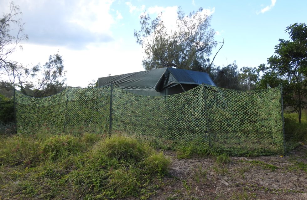
The illegal structure surrounded by camouflage netting.

https://gcwa.qld.gov.au/wp-content/uploads/2022/06/gold_coast_waterway_authority1.png 0 0 ydsgcwa https://gcwa.qld.gov.au/wp-content/uploads/2022/06/gold_coast_waterway_authority1.png ydsgcwa2019-10-11 14:38:312022-05-23 07:36:07Court supports Wave Break Island clean-up

Annual Report Now Available Online

September 27, 2019/in Latest News/by ydsgcwa

Did you know that our Sand Bypass System pumped 664,847 cubic metres of sand north of Seaway to keep waterways safe and navigable and that we maintained more than 2000 buoys, beacons and signs last year?

This is all part of the work we do to Sustain, Enhance and Promote our beautiful waterways.

You can find out more in our 2018-19 annual report which is now available here.

If you’re unable to download the report and need a hard copy, please contact our office on 5539 7350.

https://gcwa.qld.gov.au/wp-content/uploads/2020/12/shutterstock_767464711-980x550-1.jpg 550 980 ydsgcwa https://gcwa.qld.gov.au/wp-content/uploads/2022/06/gold_coast_waterway_authority1.png ydsgcwa2019-09-27 11:59:162022-05-23 07:49:30Annual Report Now Available Online

Iconic Gold Coast Sand Bypass System making the most of solar power

September 25, 2019/in Latest News/by ydsgcwa

The Gold Coast Waterways Authority has taken further steps to improve the operation of the iconic Sand Bypass System at The Spit, using a pilot solar array to help meet the operation’s day-time energy needs.

The Sand Bypass System is a critical component of the Gold Coast’s waterways network, but it consumes a large amount of power to pump sand under the Seaway and across to South Stradbroke Island to keep the waterways safe and navigable.

The solar array is starting to pay dividends by improving energy efficiency and reducing the carbon footprint of the Sand Bypass System.

The pilot system started operating in late June. An app linked to the array shows it’s already generated about 30 megawatt hours of electricity and reduced carbon emissions by over 11 tonnes, which is the equivalent of planting almost 40 trees.

The pilot is not only helping to reduce the System’s carbon footprint, it also aligns with the Queensland Government’s vision for growing a green peninsula under the Master Plan for The Spit.

Gold Coast Waterways Authority (GCWA) CEO Hal Morris said the 100-kilowatt solar photovoltaic array is generating over 600 kilowatt hours of electricity each day which is helping meet the day-time energy needs of the System.

“We’re using the app to better understand the System’s energy profile and adjusting operations to make the most of the solar energy being generated,” Mr Morris said.

“One of the changes we’ve made is to run the air compressor, which is one of our biggest users of power during the day to coincide with peak solar generating times. We use the air compressor for our tools and for backflushing the Sand Bypass System’s jet pumps.”

The contract to design, install and maintain the pilot solar system was awarded to a local company, SAE Group.

SAE Group employed a team of 20 people on the project. They were all locally based experts including engineers, designers, installers and people undertaking servicing and monitoring.

The GCWA will use the pilot to improve understanding of the solar output potential of the area, the impact of the coastal environment on solar systems and the Sand Bypass System’s energy load profile.

This information will help GCWA decide if the solar system can be expanded to further reduce operating costs and the Sand Bypass System’s carbon footprint in future.

The solar pilot builds on earlier energy efficiency measures which have included upgrading the jetty pumps to reduce power consumption during start-up operations and running the pumping system at night to take advantage of off-peak tariffs, slashing energy bills by about $150,000 over the last few years.

Below is a quick view of the system under construction.

https://www.ydsgroup2.com.au/oldgcwa/wp-content/uploads/2019/09/TLC00014-complete-panels_Trim.mp4
https://gcwa.qld.gov.au/wp-content/uploads/2022/06/gold_coast_waterway_authority1.png 0 0 ydsgcwa https://gcwa.qld.gov.au/wp-content/uploads/2022/06/gold_coast_waterway_authority1.png ydsgcwa2019-09-25 13:43:562022-05-23 07:50:17Iconic Gold Coast Sand Bypass System making the most of solar power

Waterways users study key to future planning

September 3, 2019/in Latest News/by ydsgcwa

Building a better understanding of movements on the city’s waterways network will help the Gold Coast Waterways Authority (GCWA) improve planning to accommodate a growing population and rising boat ownership.

CEO Hal Morris said an initial study undertaken by GCWA was the first serious attempt to understand past and present patterns of use on the Gold Coast’s waterways and pinpoint areas where access could come under pressure.

‘We’re a waterways city, there really is nowhere else in Australia which has a waterways network like ours.

‘People live, work and play on our waterways which also support a huge diversity of animal and plant life.

‘This users study builds on our earlier economic assessment which confirmed that the waterways are a natural asset worth $26 billion. We’re using the findings of both studies to improve our planning and make sure our decisions are based on sound information.

‘For example, we know we have 32,000 registered recreational vessels on the Gold Coast with this number expected to grow to almost 50,000 by 2031.

‘That’s not counting non-motorised craft like kayaks and stand-up paddleboards which don’t have to be registered.

‘We need to improve our understanding of where people are going when they head out on the water, what types of things they’re doing, how they interact with the natural assets of the waterways environment, and what other types of craft they’re interacting with.

‘This information will help us to better understand how busy the waterways could become and determine where the likely pressure points could be. We can then start thinking about how we’ll manage future growth in use to ensure our waterways continue to be enjoyed safely by all users.’ Mr Morris said.

The study has found that:

  • there is a lack of suitable information about the type and number of vessels using the waterways at particular times, including the sites they’re visiting, why they’re using the waterways and the quality of the user experience
  • there is an opportunity to involve waterways users in supplying information to help with future planning
  • there is an opportunity to introduce concepts such as Marine Spatial Planning as a tool to help manage the distribution of waterways users and their activities, unlocking some areas that are currently under- utilised
  • boating traffic in the northern Gold Coast waterways region (the area between the Logan River and the Broadwater north of the Seaway) is expected to triple in line with population increases in the next 25 years
  • there is a need for more information about people’s expectations and experiences of crowding to help with planning
  • user enjoyment of the waterways is closely tied to the availability of natural spaces and
  • there is a need for predictive modelling to help anticipate where the risk of incidents, accidents and injury may increase based on forecast growth in vessel numbers and waterways usage.

Mr Morris said the study was an important first step in helping the GCWA identify gaps in its knowledge and decide what further information needs to be gathered to help it come up with management solutions best suited to the Gold Coast environment.

Information gathered during the initial study will be fed into consultation sessions on the review of the GCWA’s Gold Coast Waterways Management Strategy 2014-23 planned for this financial year.

GCWA engaged Gold Coast-based Envirosphere Consulting to help it undertake the study which is available to read in full here:

Users & Uses Study Volume 1: Technical Report

Users & Uses Study Volume 2: Discussion Paper

https://gcwa.qld.gov.au/wp-content/uploads/2020/12/shutterstock_767464711-980x550-1.jpg 550 980 ydsgcwa https://gcwa.qld.gov.au/wp-content/uploads/2022/06/gold_coast_waterway_authority1.png ydsgcwa2019-09-03 12:59:132022-05-23 07:59:31Waterways users study key to future planning

Sand Bank Study In Southern Broadwater Supports Better Waterways Management

May 8, 2019/in Community, Environment / Science, Latest News/by ydsgcwa

We’re conducting a long-term study into the birds and animals living on and within the sand banks of the Southern Broadwater to help with the management of threatened species and support the protection of the Gold Coast’s waterways environmental values.

With the waterways having a natural capital value of $26 billion it’s important to ensure they’re properly managed now and into the future.

We need to adapt our planning practices to manage the likely impacts of climate change and population growth on our waterways so that they remain accessible to our marine and tourism industries and for recreational use.

This study will help us do that by providing valuable base-line data we can feed into management plans and use to assess potential risks to the birds and marine life which call these areas home.

The study will focus on the sand banks near Wave Break and Curlew Islands which have been identified as foraging areas for shorebirds such as the Critically Endangered Eastern Curlew.

This is the first time we’ve done a formal survey of the banks and the creatures living on and within them.

Improving our understanding of these areas gives us the chance to anticipate changes which might be triggered by population growth and climate change and head off any adverse impacts.

We’ve engaged a final-year student to undertake the study as part of our participation in Griffith University’s Industry Affiliates Program.

The Spit Master Plan has identified Wave Break and Curlew Islands as popular recreation areas and we need to ensure that they’re managed in a way that enables people to enjoy them for years to come.

The study will focus on benthic organisms which are organisms living in the sand bank surface down to a depth of about 20 centimetres.

We’re aiming to map the sensitivity of the sandbanks and better understand the ecological processes which take place on them such as the relationship between the marine life in the benthic layer and the numbers of shorebirds and their feeding habits.

Information gathered will also be fed into the GCWA’s Sand Management Plan which determines where and how sand recovered through dredging is used for shoreline replenishment and the impact that process has on creatures living in the benthic layer.

The study will concentrate on:

  • Identifying any invertebrates found in the benthic zone such as worms
  • Examining sediment particles to determine size and how they’re distributed on the banks
  • Counting shorebirds and
  • Reviewing any existing mapping.

It’s anticipated that the study will take place over several years, enabling the GCWA to build up a solid understanding of the ecological significance of the sand banks and adjust their management as needed.

https://gcwa.qld.gov.au/wp-content/uploads/2022/06/gold_coast_waterway_authority1.png 0 0 ydsgcwa https://gcwa.qld.gov.au/wp-content/uploads/2022/06/gold_coast_waterway_authority1.png ydsgcwa2019-05-08 12:53:372022-05-23 13:46:35Sand Bank Study In Southern Broadwater Supports Better Waterways Management

Buoy Mooring Strategy

October 22, 2018/in Latest News/by ydsgcwa

GCWA is working to improve the management of buoy moorings in Gold Coast waters.

These improvements flow from the Buoy Mooring Review in 2014 and our recent Buoy Mooring Management Strategy developed to accommodate the Gold Coast’s rapidly increasing population, while embracing new technology to improve safety and reduce the impact of buoy moorings on the marine environment.

We’re looking closely at the conditions for all buoy mooring authorities and will be gradually phasing out traditional block and tackle buoy moorings in favour of environmentally friendly moorings.

Read more about buoy moorings including the latest updates and environmentally friendly moorings here

https://gcwa.qld.gov.au/wp-content/uploads/2018/10/BuoyMooring.jpg 640 960 ydsgcwa https://gcwa.qld.gov.au/wp-content/uploads/2022/06/gold_coast_waterway_authority1.png ydsgcwa2018-10-22 15:15:452022-05-23 14:00:04Buoy Mooring Strategy
Page 9 of 9«‹789

–

  • Spring clean for Wave Break Island ahead of summer
  • Simpler speed rules for Paradise Point Channel trial
  • Paradise Point Channel speed limit trial
  • 2026 Waterways Management Program released
  • Dredging underway in the Gold Coast Seaway
  • Keeping the Gold Coast waterways accessible and safer – Compliance Update
  • Investing in the Sand Bypass System for the Future
  • Operation Clearwater delivers improvements for Gold Coast waterways
  • Operation Clearwater delivering results across the Broadwater
  • Gold Coast Seaway marks 40 years of coastal engineering and connectivity

  • 40-44 Seaworld Drive
    Main Beach Qld 4217

  • PO Box 107
    Southport Qld 4215

  • 07 5539 7350
  • mail@gcwa.qld.gov.au

Who’s Who in the Blue

Who’s Who in the Blue explains who is responsible for managing, protecting and
regulating Queensland’s waterways, particularly on the Gold Coast.

It clarifies agency roles across safety, environmental protection, pollution response,
compliance and infrastructure, helping avoid confusion and duplication.

Overall, it’s a quick reference guide that supports coordination, accountability and
effective waterway stewardship.

Download Who’s Who in the Blue

Acknowledgement of Country

The Gold Coast Waterways Authority acknowledges and pays respect to the traditional custodians, the Yugambeh peoples of South East Queensland, including the Kombumerri, Mununjali, Wangerriburra, Bullongin and other clans, and their Elders past, present and emerging. We recognise their unique and ongoing spiritual and cultural connection with the land and waters of the Gold Coast area.

Any damaged or missing aids to navigation such as beacons, buoys, markers or signs, should be reported as soon as possible on 07 5539 7350.
For community engagement, communications or media enquiries please contact mail@gcwa.qld.gov.au

Access, Management & Destinations

  • Access & Management

    Information on Anchoring & Mooring, Boating, Dredging, Operations Team & Tidal Works

    Learn More

  • Our Destinations

    GCWA managed multi-use destinations, building infrastructure for commercial and recreation use of Gold Coast waterways.

    Learn More
© 2026 Copyright - Gold Coast Waterways Authority | Website By: YDS
  • Facebook
  • Instagram
  • LinkedIn
  • Right to Information
  • Privacy
  • Disclaimer
  • Copyright
Scroll to top

Status: Closed

The Sand Bypass System (SBS) jetty is a working platform and is closed to the public whenever construction activity, sand pumping operations or maintenance works are underway, or during severe weather events.

For safety reasons, the jetty will remain closed until the end of 2026 while essential maintenance and ongoing sand pumping operations continue. We appreciate your understanding.

To find alternative jetty facilities, please visit the GCWA Destinations Map.

Disclaimer

GCWA’s tidal works mapping is a public resource for general information purposes only.

The tidal works mapping is not a cadastral survey or hydrographic survey product. It should not be relied upon as the basis for making any decision, whether a business, conveyance, development, property boundary, property description, property title, property transaction, or any other decision.

GCWA makes no warranty, representation, or guarantee, express or implied, as to the accuracy, completeness, content, reliability, suitability, or timeliness, with respect to the information or related graphics.

GCWA has taken care in preparing the mapping information, but accuracy is not guaranteed, and the information contained in the tidal works mapping must not be construed or used as a legal description of any property. Under no circumstances will GCWA be liable for any damages whatsoever, including business interruption, loss of business information, loss of data, loss of profits, property valuation, or any other damage, arising from use or misuse of this tidal works mapping.

Any errors or omissions should be reported to GCWA in writing by email to mail@gcwa.qld.gov.au.


Status: Closed

The SBS jetty is a working platform and for safety reasons is not open to the public during construction projects, when operating, undergoing maintenance or during severe weather events.

Until the end of 2025 while maintenance works, and sand pumping operations take place, the jetty will be closed.

Your understanding is appreciated, to find alternative jetty facilities please visit the GCWA destinations map.

Disclaimer

Tidal works mapping information

GCWA’s tidal works mapping information is a public resource for general information purposes only. It is not a cadastral survey or hydrographic survey product. It should not be relied upon as the basis for making any decision, whether a business, conveyance, development, property boundary, property description, property title, property transaction, or any other decision. GCWA makes no warranty, representation, or guarantee, express or implied, as to the accuracy, completeness, content, reliability, suitability, or timeliness with respect to the information or related graphics. GCWA has taken care in preparing the mapping information, but accuracy is not guaranteed, and the information contained in the GCWA Open Data Portal must not be construed or used as a legal description of any property. Any errors or omissions should be reported to GCWA in writing by email to mail@gcwa.qld.gov.au. Under no circumstances will GCWA be liable for any damages whatsoever, including business interruption, loss of business information, loss of data, loss of profits, property valuation or any other or damage arising from use or misuse of this mapping information.

Go To GCWA Open Data Portal

I want to talk to someone about...

I want to talk to someone about… Officer Phone number
reporting oil pollution, a significant navigational hazard, or a damaged aid to navigation.Waterways Vision and Waterways Management Strategy Waterways Operations Crew 07 5539 7350
a media issue Senior Communications Advisor 07 5539 7350
a project Program Delivery team 07 5539 7350
the Sand Management Plan Planning and Innovation team 07 5539 7350
Waterways Access

·         Dredging

·         Public pontoons & other marine infrastructure

·         Sand Bypass

Program Delivery team 07 5539 7350
Waterways Management Waterways team 07 5539 7350
·         Anchoring and Mooring Compliance

·         Aquatic Events

·         Doug Jennings Park

·         Abandoned vessels

·         Aircraft take-off and landing permits

Waterways team 07 5539 7350

07 5539 7350

·Navigation Aids

·Signage

·Pollution

Waterways Operations Crew 07 5539 7350
Marinas Waterways team 07 5539 7350
Private pontoons, jetties & boat ramps Waterways team 07 5539 7350
Buoy Moorings Planning and Innovation team 07 5539 7350
Executive Governance 07 5539 7350
GCWA Board, CEO matters 07 5539 7350
Community Engagement, Sponsorships & Partnerships Community Engagement Officer 07 5539 7350
Business Management Business Services team 07 5539 7350
Accounts Payable – General Accounts Business Services team 07 5539 7350
Accounts Payable – Projects Program Delivery team 07 5539 7350
Accounts Receivable Business Services team 07 5539 7350
Sand Bypass Status

Status: Closed

The SBS jetty is a working platform and for safety reasons is not open to the public during construction projects, when operating, undergoing maintenance or during severe weather events.

Until the end of 2025 while maintenance works, and sand pumping operations take place, the jetty will be closed.

Your understanding is appreciated, to find alternative jetty facilities please visit the GCWA destinations map.